Calamity Mesa Airstrip
By Jerry Smith
September 3, 2011
I had been down on myself for
failing to find the road(s) to the airstrip on the top of the mesa on the last
trip to Calamity Mesa. The computer maps
showed a road to the upper end and another to the lower end of the airstrip.
The one from the lower end I had convinced
myself that I had found, but that road had a long piece missing in the middle
that would require some serious work to get around or through. The Colorado geology can be rough on roads in
the backcountry.
Most often you just have rocks or
trees falling down onto the road from above or places where the runoff has cut
a channel either across or along the road surface creating serious obstacles.
But then there are the times when
the whole hillside simply sloughs off down the hill. I’ve seen two places where the hillside
slipped down and the road surface was literally intact downhill several yards
from where it had been constructed. It’s a strange site to happen on.
When that happens, it’s hard to convince
your Jeep to just take the road where it is.
That vertical jump down and then back up can be puzzling.
This time the whole hillside had
moved destroying what looked to be 100 yards of the road altogether.
That finding had been late in the
day so I did not take time to explore what it was going to take time to get by
this obstacle.
A few days later, I was dropping
off some CDs of pictures I had promised Hugh Phillips of Safari Ltd, a Toyota
service shop.
Hugh and I got to talking about our
trips on the Rock Junction event back in early June and Calamity Mesa came
up. I mentioned that Mike Click and I
had made the attempt to find our way to the airstrip without success and Hugh
said; “I was just up there.” We
discussed the roads to it for quite a while.
He had gone from the top and had followed the road from the bottom of
the strip to a place where there were trees downed across the trail and he
turned around.
Thinking I knew approximately where
he had turned around… which I thought would have been just up the canyon from
where the road had disappeared, I set out to go where he said you could get
there.
The trip as far as Calamity Camp
and the New Verde mine went very smooth.
Being alone generally allows things to go that way. Having no other schedules allow you to do
whatever, whenever.
Coming to the second road on the
right that I knew climbed to the top of the mesa, I took it and followed it to
just over the rim. There it forks and I
now knew to take the left fork for a little way to another fork going uphill to
the left.
Some of the hill climb was fairly
rough going but the road got quite easy going as it hit the top. Soon I could see the airstrip to the right of
the road.
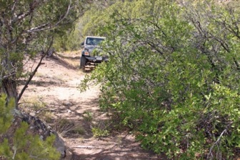
After a picture of the strip from
the north end, I followed the strip to the other end and then the road down the
mesa. The road travels through some
intermittent typical juniper and pine areas and then through some wide meadow
like areas.

Looking down the Calamity Mesa Air
Strip
Along this stretch of real estate,
the road/trail appeared more abandoned than most you find in this world of ATVs
and 4x4s. There were zero signs of ATV
width tracks in the tall grass growing on the roadway. The ATV crowds don’t seem to heavily use
Calamity Mesa. I think some of the
trails are too rough for the majority so they seem to go elsewhere.
The 20-mile loop road we reopened
about 3-years ago still has very little traffic of any kind. The first wash (the “Gate Keeper Wash”) about
a mile below the New Verde Mine across from Calamity Camp would stop anyone not
in a very well equipped vehicle. Even
the ones who make it through that wash will balk at the next one.
The two mines on the map along this
mesa top road were not apparent as we passed by. Many of the old Uranium mines left little or
no traces when they closed up. Coming to
a tee in the road/ trail, I took the right fork following my nose to where I
thought I would find where Hugh had turned around. This first time out this way, I came to what
I thought was the end of the trail where there was slick rock intermingled with
low growth, so turned around to take the left fork.
Before turning around though, I had
to get out and admire the great views of Flat Top Mesa, Maverick Creek valley,
and across the Delores River to Sewemup Mesa and the Cottonwood Creek
area. This country is mighty easy on the
eye if you take time to look. In fact,
you could just sit and gaze for hours with a complete sense of contentment.

Flat Top Mesa
The trail on the end of this right
fork is on some near slickrock conditions and finding any trail is more by
feeling than it is by seeing. You just
have to imagine your way along. Have you
ever tried tracking an ant across a rock?
At the end of the left fork, I got
out and walked along the cliff rim to see what I could see. I recognized some of the surrounding
countryside from the many previous trips.
Coming around the west side of the cliff I got a glimpse of a road below
deep in a canyon that ran somewhat northerly up into the mesa top back in the
direction I had just driven from.
So,
after some more scouting, I drove back to see if this was the road Hugh had
driven down. I often find that following
my nose turns out to be the right thing to do.
This was looking like the nose knew again.
Back near where I had turned around
the last time, I pointed Happy Trails down to the left and followed a wide spot
through the trees. Soon, the road coming
from the bottom seemed to come out of nowhere and down it we went.
Most of this road looked to have
had little to no traffic for quite some time.
Zero tracks showed ahead and there was a lot of brush growing into the
road.
Finally, I came to the trees Hugh
had turned around at. They were in the
bottom of the dry wash and these were some fairly large old dead pines. Lying there across the road/wash, they had
created something of a dam in the watercourse.
In a place like this, that is usually a good thing from an erosion
stopping point of view.
They would have taken a lot of winching
and cutting to make the road passable.
Having a lot of experience with situations like this, I did a little
foot recon to see if the work required would be worth the effort.
I’ve been with others who would
just set to work with the removal process only to find another closure just
yards down the trail negating all the hard work.
I learned a long time ago to take a
few minutes and walk the trail for a while past the obstacle to make sure the
work won’t be in vain. This time, other
than a lot of oak growing across the road ahead, the work looked like it
wouldn’t be wasted.
On the return to the downed trees,
I looked over a little hump off the roadside and thought it looked like with a
very little limb trimming; I could simply bypass the downed timber and leave
the dam intact.
Rather than the
estimated hour of winching, I had a clear path in about 20 minutes and soon was
sweating up a storm cutting oak brush back from the road.
This exercise happened several
times in the next approximate mile of road.
The growth was extreme. One
place, the road was only about a yard wide between the oak brush on one side
and a pine tree on the other. That is why I carry a saw and some heavy
shears. Rather than just turn around
when the road is overgrown, we go to work and reopen it. Admittedly, Happy Trails isn’t much help in
these situations,
but she appreciates the wider trail.
Oak brush
growing over and in the road.
I don’t mind a good obstacle, but
leaving good paint on the bushes is nothing but being lazy. Happy Trails has some scratches, but the
tools come out pretty easily to keep scratches to a minimum.
Soon the elevation began thinning
the oak out and the going got better until we came to a large rock in the
middle of the road on the crest of a little hill in a fairly narrow place. This was nearly a deal breaker, but after
some serious assessment, I decided to chance jumping over it. Expecting to have to return this way made
jumping it seem a little haphazard, but that’s “Jeeping with Jerry”.
Below the rock was a long
off-camber stretch that tightened the seat covers a little. Then it was just the occasional rock or wash
to deal with for quite a way down the valley.
All of the sudden, the road seemed
to almost disappear. There was a wide
opening ahead, but there were no tracks or even worn trails through the wide
spot. It became just a lot of small
rocks and rough going. Expecting to
come to the end of the trail any time, we came to a tee into another road.
Taking a left turn, this road became
familiar soon after driving for a few hundred yards. This was 11.5 Rd, the road below the New
Verde Mine and Calamity Camp. To mutilate a line from the song “East Bound and
Down”, we had just done what had been said could not be done.
The road off the mesa top
intersected in a place that no more looked like an intersection than my
hood. We’ve driven by this place several
times and never even suspected it was an intersection. After marking it with a serious cairn and GPS
waypoint, we headed in the direction of the rest of the Calamity Mesa Loop.
This loop road is always a great
day in the Jeep. Several times it has
been a lot of work to make it clear around but this time it was just a pleasure
trip… if a class 7 trail can be called a pleasure.
Take a look at the picture of Happy
Trails on “Articulation Station”, just one of the obstacles on the Calamity
Loop trail. If you can’t do this several
times in 20-miles, don’t try this trail!
It is full of this kind of Jeeping.

Happy Trails on “Articulation Station”

Happy Trails on “Articulation Station”
This was a near perfect day in the great
American backcountry. Why not “perfect”
you ask?
There’s the matter of a certain
road with a section missing that needs some questions answered… like where does
it go? Ahhhh, that will give us another
adventure to live at a later date.
Just knowing there is one more
trail open in the world is enough to make your heart swell.
Always remember this important
point… when you come to a fork in the road, take it! That may be where the adventure is!
Copyright Happy Trails 4wd
2011-2013, All rights reserved.
No comments:
Post a Comment